
San Isidro is the fourth district of Atenas. It is known as a transition zone between the town center and the higher lands of the canton, which gives it a cooler climate and privileged views of the Central Valley and the surrounding mountains.
History
Like the rest of Atenas, San Isidro was originally inhabited by the Huetar indigenous people under the leadership of the cacique Garabito. The district’s history is closely tied to the expansion of coffee cultivation and subsistence farming during the 19th century. A key historical milestone was the creation of San Isidro School in 1906. Initially, classes were held in private homes until the first school building was constructed in the 1930s on land donated by members of the community. As the center of Atenas became more populated, families gradually moved toward the higher ridges in search of fertile soil and cooler air.
Description and Characteristics
Today, San Isidro de Atenas is consolidating itself as a district that balances rural tranquility with residential and tourist growth driven by its temperate climate and mountain landscapes.
- Agricultural Tradition: Historically, the district has been an important agricultural area, known for its coffee plantations and its proximity to the old railway route that once connected the Central Valley to the Pacific.
- Area and Elevation: The district covers approximately 14.4 km² and has an average elevation of 1,000 meters above sea level, making it significantly higher than downtown Atenas.
- Atmosphere: It is a rural-residential district known for its lush green hills, coffee farms, and scenic viewpoints.
Main Neighborhoods and Sectors
- San Isidro Centro: The main hub where the church, the school, and the local plaza are located.
- Altos de Naranjo: The highest area of the district, popular for luxury country homes (quintas) and scenic viewpoints.
- Bajo Cacao: A rural sector characterized by farmland and natural surroundings.
- Morazán: A rural hamlet that preserves the coffee-growing traditions of the region.
- Pavas: A community with a strong agricultural heritage where coffee cultivation remains part of the everyday landscape. The community frequently organizes the “Caminata de las Cataratas” (Waterfall Walk).
- Pato de Agua: A high-altitude area (over 1,200 meters) that serves as a reference point for the road intersection leading toward Estanquillos.
Places of Interest
- El Toledo Coffee Tour: A small coffee farm that offers an educational experience focused on organic and sustainable coffee production.
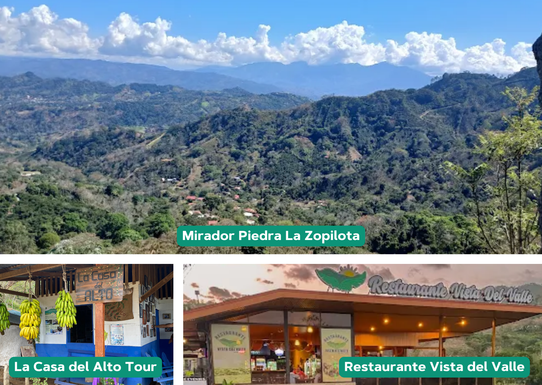
- Restaurante Vista del Valle: Known for offering one of the best panoramic views in the area, with live music on weekends and a varied menu. It is a popular place to watch the sunset.
- Restaurante Natural Hut: Located on Calle Pavas, it offers a family-style dining concept surrounded by greenery and fresh mountain air. It specializes in traditional Costa Rican cuisine.
- Mirador Piedra La Zopilota: Considered the highest viewpoint in the canton of Atenas, located in the upper area of Altos de Naranjo. It offers impressive views of the Greater Metropolitan Area (GAM), the western region of the country (Palmares and San Ramón), and the Central Pacific. The route is very popular among mountain biking (MTB) and hiking enthusiasts. Visitors can also reach the viewpoint through La Casa del Alto Tour, which often includes traditional wood-fired meals prepared in an authentic local home.
Sources:
Images courtesy of Gabriela Araya and Restaurante Vista del Valle.